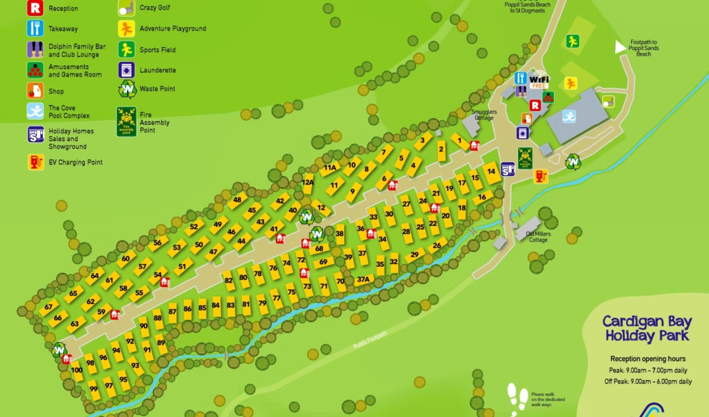
Cardigan Bay Holiday Park Map
Holiday Park Maps Maps

Cardigan Bay Holiday Park Map

The Cardigan Bay Holiday Park map is key to navigating this five-star family park. It precisely locates the various recreational amenities, including the fun crazy golf course and the expansive adventure playground, ensuring children have ample space to play. A dedicated sports field provides room for active pursuits.

For convenience, the map highlights the launderette for guest laundry needs and clearly marks the waste point for proper disposal. Crucially, fire assembly points are indicated for safety. The reception building is a central point for queries and assistance.

When hunger strikes, the map directs guests to the on-site takeaway options, and a well-stocked shop caters to daily essentials. In a nod to modern travel, the map also pinpoints the EV charging point, making it convenient for electric vehicle owners. Beyond the park, the map implicitly shows the short walk to Poppit Sands beach, enhancing the overall holiday experience.


Cardigan Bay Holiday Park Google Map

Google Maps provides an excellent visual overview of Cardigan Bay Holiday Park. Its satellite view allows users to see the park’s exact location at Poppit Sands, the layout of the static caravans, and the positioning of key amenities like the indoor pool complex, reception, and play areas. Users can often get a sense of the proximity to the beach (just 300 yards away) and the surrounding natural beauty. Directions are easily accessible, and reviews often highlight the clean facilities and friendly atmosphere, giving prospective visitors a comprehensive preview of their stay.