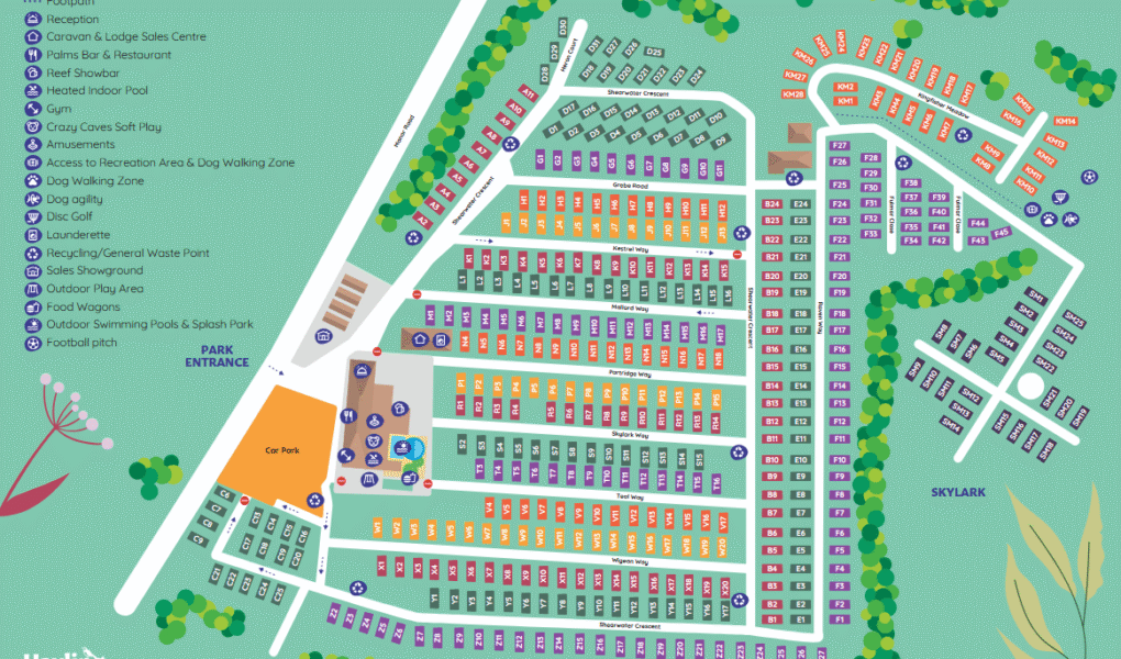
Hayling Island Holiday Park Map
Holiday Park Maps Maps

Hayling Island Holiday Park Map

The Hayling Island Holiday Park map is a comprehensive guide to this vibrant coastal resort. Upon arrival, the Reception is clearly marked, alongside the Caravan & Lodge Sales Centre for those interested in ownership.

For dining and entertainment, the map highlights Palms Bar & Restaurant and the lively Reef Showbar. Families will appreciate the leisure facilities, including the Heated Indoor Pool, Outdoor Swimming Pools & Splash Park, and the Crazy Caves Soft Play. An Amusements arcade provides further indoor fun, while a well-equipped Gym caters to fitness enthusiasts.

Outdoor activities are abundant, with dedicated Access to Recreation Area & Dog Walking Zone, a specific Dog Agility course, and a unique Disc Golf course. An Outdoor Play Area and a Football pitch offer more traditional recreation. Practicalities are covered with a Launderette, Recycling/General Waste Point, and a Sales Showground for viewing models. Various Food Wagons are also typically indicated for convenient dining options.


Hayling Island Holiday Park Google Map

Google Maps offers a fantastic virtual preview of Hayling Island Holiday Park. Its satellite imagery clearly displays the park’s layout, showing the numerous caravan and lodge pitches, the distinct indoor and outdoor swimming pool complexes, and the large central entertainment buildings like the Reef Showbar. You can also spot the football pitch, outdoor play areas, and even get a sense of the proximity to the surrounding coast and the nearby Manor Road. This visual aid is invaluable for planning routes within the park and understanding its setting on Hayling Island.