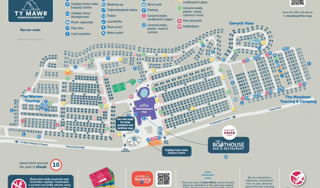
Ty Mawr Holiday Park Map
Holiday Park Maps Maps

Ty Mawr Holiday Park Map

πŸ–οΈ Exploring Parkdean Resorts Ty Mawr

The Ty Mawr Holiday Park map is essential for navigating this action-packed resort in North Wales, nestled near the hills of Gwrych Castle. It provides a clear layout of the caravan sectors, premium lodges, and walking paths to help you easily locate your accommodation and find the quickest route to the park’s vibrant areas.

Use the map to guide you straight to the lively Adventure Village, home to high-flying zip lines, a high ropes course, bungee trampolines, adventure golf, and multi-sports courts. For relaxation and dining, locate The Boathouse Bar & Restaurant, the indoor pool with its interactive water flume, and The Showbar entertainment venue.

Essential facilities like the park reception, Nisa store, launderette, and coastal footpaths leading toward Abergele and Towyn beaches are completely mapped out. Don’t forget to check the southern perimeter paths on the map for a stunning view of Gwrych Castle illuminated at night!

Verified Map
Current Version:

πŸ—ΊοΈ How to Navigate the Interactive Map

πŸ›°οΈ

Toggle Map Views: Switch to Satellite View to pinpoint individual caravan avenues, luxury lodge sectors, and outdoor facilities across the resort, or use the Standard Map for a clean overview of holiday home zones, sports courts, and vehicle routes.

🚢

Explore Street View: Take a look at the main park entrance and the surrounding coastal roads right outside the resort gates, helping you easily identify key landmarks for a smooth arrival.

Interactive Map