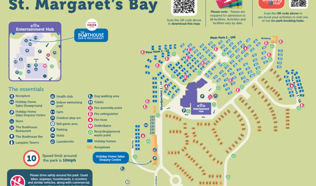
St Margaret's Bay Holiday Park Map
Holiday Park Maps Maps

St Margaret’s Bay Holiday Park Map

🏖️ Exploring Parkdean Resorts St Margaret’s Bay

The St Margaret’s Bay Holiday Park map is essential for navigating this premium retreat nestled atop Kent’s iconic White Cliffs of Dover. Use it to easily locate your accommodation across the luxury lodge avenues, quiet bungalow cul-de-sacs, and main caravan areas, as well as finding direct footpaths down to the beach.

Wellness & Dining Hub: The map guides you straight to the standout Balance Spa & Health Club, which features a 22-metre indoor heated pool, relaxation pool, sauna, and steam room. Right nearby, you can pinpoint the upgraded Boathouse Bar & Restaurant with its spacious outdoor dining terrace.

Activities & Essentials: Easily spot the massive five-acre recreation field (ideal for dog walking and family games), the indoor soft play area, Hover Archery range, and the Showbar entertainment venue. Main reception, EV charging points, and the Nisa convenience store are all clearly flagged for a seamless stay.

Verified Map
Current Version:

🗺️ How to Navigate the Interactive Map

🛰️

Toggle Map Views: Switch to Satellite View to check out individual luxury lodge avenues, quiet bungalow rows, and main caravan districts, or use the Standard Map for a simplified layout of holiday homes, vehicle parking, and paths.

🚶

Explore Street View: Drop onto the park roads to preview the layout around the Balance Spa & Health Club, the Boathouse Bar & Restaurant complex, or the main entrance, ensuring a stress-free arrival at the White Cliffs coast.

Interactive Map