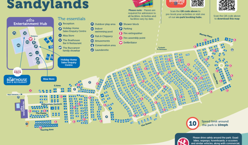
Sandylands Holiday Park Map
Holiday Park Maps Maps

Sandylands Holiday Park Map

๐Ÿ–๏ธ Exploring Parkdean Resorts Sandylands

The Sandylands Holiday Park map is your essential guide for navigating this lively Ayrshire coastal resort. It provides a clear layout of the caravan zones, the central leisure hub, and the quickest walkways down to the local sandy beaches and nearby rail links.

Use the map to find core social spots like The Beacon Bar & Restaurant, the Showbar entertainment venue, the heated indoor pool, and popular on-site takeaway options. It also highlights outdoor activities including the adventure playground, the MUGA multi-sports court, and the Nisa convenience store.

Beyond the accommodation districts, the layout showcases your proximity to championship golf courses and nearby Ardrossan Harbour for day trips to the Isle of Arran. Top Tip: Check the map for the footpath to the local train stationโ€”the fastest car-free route to Glasgow, Ayr, or Prestwick.

Verified Map
Current Version:

๐Ÿ—บ๏ธ How to Navigate the Interactive Map

๐Ÿ›ฐ๏ธ

Toggle Map Views: Switch to Satellite View to pinpoint individual caravans and pitch locations across the resort, or use the Standard Map for a simplified view of holiday home avenues, facility parking, and seaside footpaths.

๐Ÿšถ

Explore Street View: Drop onto the park roads to preview the layout near main reception, the central leisure hub, and The Beacon Bar & Restaurant, making it easy to find your route down to the local sandy beach.

Interactive Map