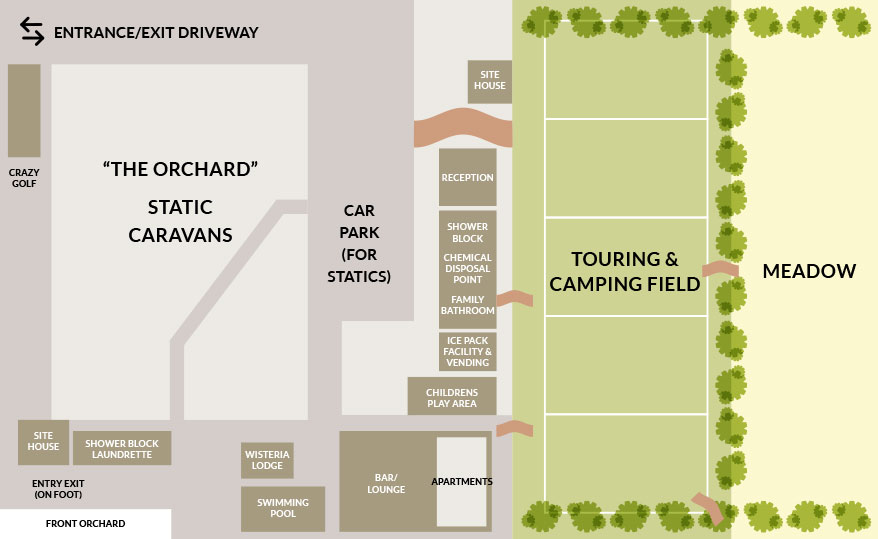
Appuldurcombe Gardens Holiday Park Map
Holiday Park Maps Maps

Appuldurcombe Gardens Holiday Park Map

🌲 Exploring Appuldurcombe Gardens Holiday Park

The Appuldurcombe Gardens Holiday Park Map, situated within an Isle of Wight National Landscape, offers a clear guide to its serene 14-acre grounds. The map distinguishes between various accommodation types, from static caravans nestled within historic orchard walls to spacious touring and camping pitches, providing an essential resource for navigating the park.

Key facilities are prominently marked on the map, including the Core Complex which houses a licensed cafΓ© and lounge, and the inviting outdoor heated swimming pool.

Guests can easily locate amenities such as the laundrette, children’s play area, and miniature golf course. The map further aids in navigating the park’s pathways and identifying access points for walking and cycling trails directly from the site, ensuring a relaxing holiday experience.

Verified Map
Current Version:

πŸ—ΊοΈ Interactive Map Location

Our interactive map of Appuldurcombe Gardens Holiday Park allows you to explore the grounds from multiple perspectives. Use the Satellite view for a bird’s-eye look at the 14-acre setting, switch to Map for a clear structural plan of the pitches and facilities, or dive into Street View to explore the park’s access paths.