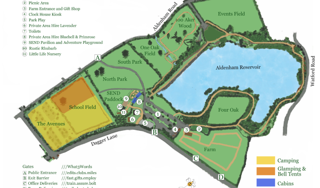
Aldenham Country Park Map
Holiday Park Maps Maps

Aldenham Country Park Map

Aldenham Country Park Map is an essential guide for exploring this 100-acre haven of countryside, located just 12 miles from central London. As the Aldenham Country Park Map illustrates, the park is expertly laid out to cater to families, walkers, and nature enthusiasts alike. By following the detailed pathways shown on the grounds, visitors can easily navigate between the popular 60-acre sailing lake and the various woodland trails that meander through the historic Hertfordshire landscape.

Centrally featured are the park’s primary attractions, including the Farm Park, where children can interact with rare breed animals, and the magical Winnie the Pooh’s 100 Aker Wood. The layout also highlights vital guest facilities such as the Clock Tower Café, the large adventure playground, and the dedicated camping and glamping fields for those staying overnight. Whether you are searching for the best fishing spots along the reservoir or planning a route to the sensory forest, this comprehensive guide ensures you can enjoy every corner of the park with ease.

✓ Latest Map Current Version:

Navigate Aldenham Country Park with Google Maps

Use the buttons below the map to toggle between Satellite View to see the expansive 60-acre reservoir and woodland canopy, or Standard Map for a clear view of the park trails and activity zones. You can also use Street View around the main car park and Farm Park entrance to get familiar with the Hertfordshire countryside terrain before you arrive, making it easier to find your way to the Clock Tower Café, the adventure playground, or the magical trails of Winnie the Pooh’s 100 Aker Wood.

Our Location

Interactive Google Maps