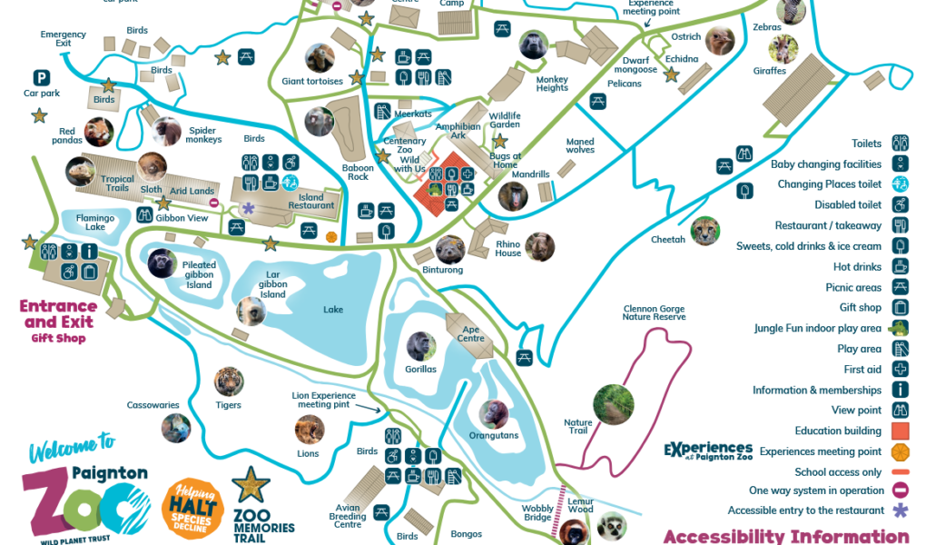
Paignton Zoo Map – Your Essential Visitor Guide
Paignton Zoo Environmental Park in Paignton, Devon is one of the UK’s top wildlife destinations. Our Paignton Zoo Map helps visitors plan their route, locate over 2,000 animals, and navigate the zoo’s 80 acres of gardens and habitats efficiently.
For easy arrival, set your Sat Nav to TQ4 7EU. The zoo is located on Totnes Road, just a short distance from Paignton town centre.
Main Attractions at Paignton Zoo
- Animal Exhibits: Use the map to find the Savannah (Giraffes, Zebras, Cheetahs), the Gorilla Mountain, and the Desert House. You can also see Tigers, Lions, Orangutans, Red Pandas, and the rare Amphibian Ark.
- Special Experiences: Check the map for animal talk meeting points, the Lion Experience, and the Tropical Trails walkthrough.
- Play Areas: Kids can enjoy the Little Grubs soft play (check for seasonal opening) and the various outdoor adventure play zones.
- Visitor Facilities: The Island Restaurant, various takeaway kiosks, the gift shop, and dedicated picnic areas are clearly marked.
- Accessibility & Mobility: The map highlights “Easy Access” routes (shallow inclines). Note that some areas like the Wobbly Bridge or the path to the tigers have steeper gradients.
Why Use the Paignton Zoo Map?
- Identify the best routes to see popular animals like the Black Rhinos and Sumatran Tigers.
- Locate the Changing Places toilets and disabled facilities located near the entrance and the Island Restaurant.
- Plan your day around feeding sessions and educational talks.
- Find the main and overflow car parks, ensuring you know where to return at the end of the day.
Top Tip: Paignton Zoo is hilly! Use the map to follow the “Green Route” if you are using a wheelchair or pushchair to avoid the steepest inclines around the back of the zoo.
Using the Paignton Zoo Map ensures a smoother day out, helping you explore everything from the Avian Breeding Centre to the Giant Tortoises with ease.
Paignton Zoo Google Maps – Explore the Zoo Virtually
Satellite View
Explore Paignton Zoo from above with our satellite view, showcasing enclosures, pathways, lakes, and landscaped gardens for easy trip planning.
Standard Map View
Use the Paignton Zoo map view to locate walking routes, animal exhibits, cafés, picnic areas, and visitor facilities, making navigation simple during your visit.
Street View
Get a ground-level perspective with Street View, walking virtually through entrances, pathways, and key points of interest to familiarise yourself with Paignton Zoo before arrival.