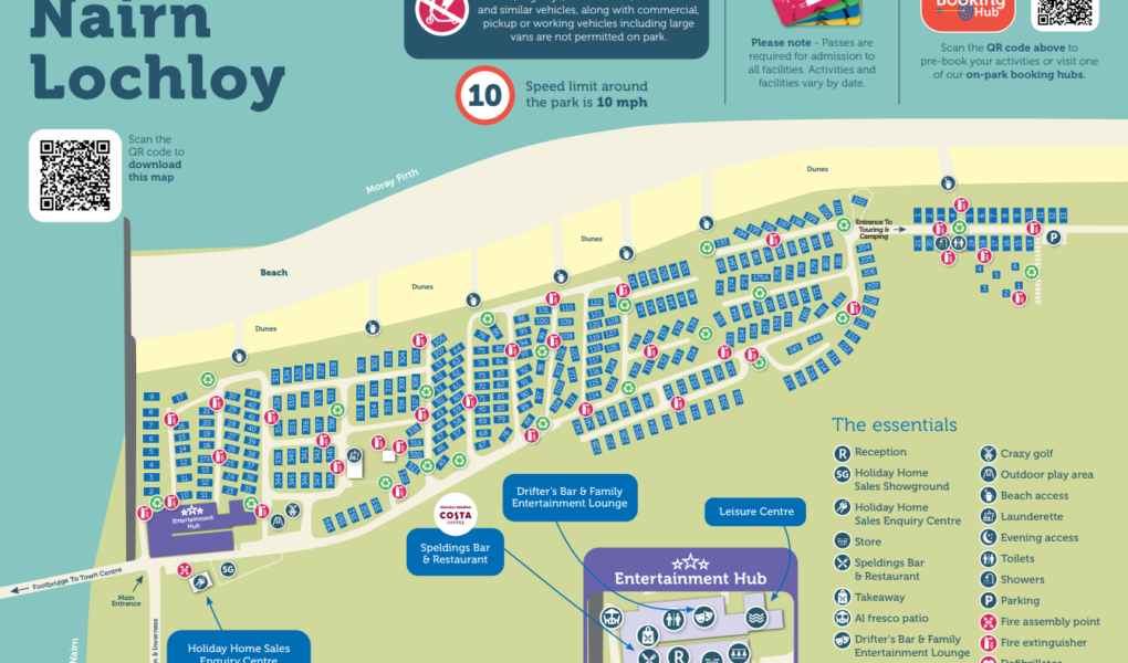
Nairn Lochloy Holiday Park Map
Holiday Park Maps Maps

Nairn Lochloy Holiday Park Map

πŸ–οΈ Exploring Nairn Lochloy Holiday Park

The Nairn Lochloy Holiday Park map is your essential navigator for this stunning Highland retreat. Nestled beside Nairn East Beach, a championship golf course, and the marina, the layout guides you easily from the quiet holiday home avenues to the central hubs and scenic coastal paths.

Use the map to find the indoor heated pool complex, complete with a sauna, and Spelding’s Lounge Bar & Restaurant featuring an outdoor patio overlooking the marina. The nearby Drifters Bar hosts family evening entertainment alongside the amusement arcade.

The layout details outdoor activities like the crazy golf course, multi-sports court, and adventure playground. Top Tip: Use the map to locate the resort footbridge for a quick walk over the river into Nairn town center, or head to the marina edge to spot the Moray Firth’s resident bottlenose dolphins!

Verified Map
Current Version:

πŸ—ΊοΈ How to Navigate the Interactive Map

πŸ›°οΈ

Toggle Map Views: Switch to Satellite View to pinpoint individual harbor-view lodges and premium caravan layouts tucked by the marina, or use the Standard Map for a simplified layout of the Highland holiday home zones, guest parking, and pathways.

🚢

Explore Street View: Drop onto the park paths to preview the complex around the main reception, Spelding’s Lounge Bar, and the marina edge, ensuring a clear route to the town footbridge or down to the sand dunes on arrival.

Interactive Map